Clean boundary
The review every Google Earth file goes through on loading, and what to do with open lines, overlaps, survey maps, finished layouts and field surveys.
Clean boundary is the review every Google Earth file (.kmz or .kml) goes
through when you load it. It sorts what the file holds into plots, areas, lines
and pins, and fits them to what the layout needs. A file with nothing to decide
loads straight away, with no window. A file with something to decide opens the
Clean boundary window, and Save clean KMZ and load writes a corrected
copy beside the original and loads that.
The review changes only what you see in the window: your original file is never altered. How to draw a file so that it asks nothing is in Boundary file requirements.
Reading the file
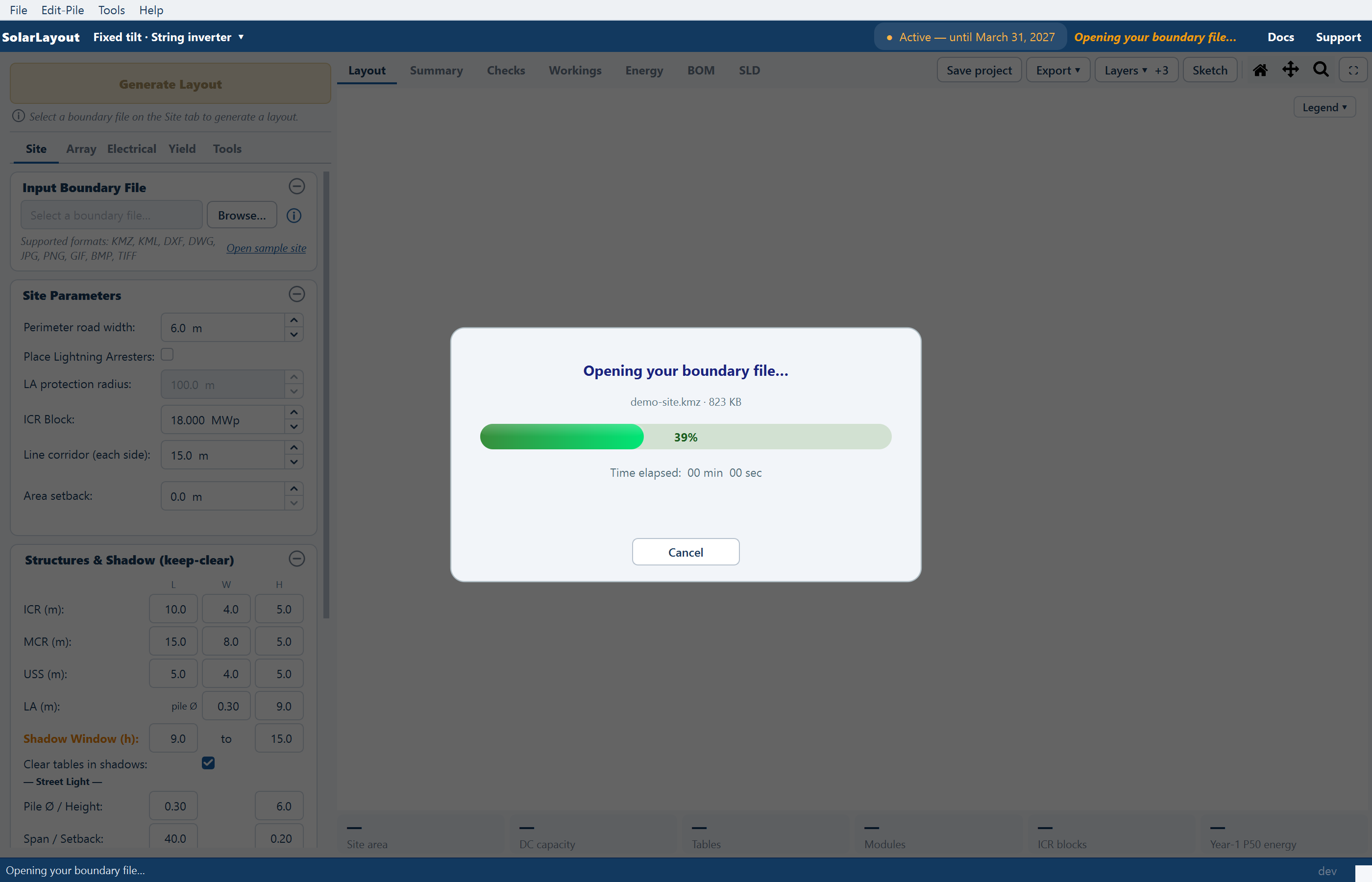
Clicking Browse… on a Google Earth file starts the reading under a progress card. A file that reads quickly never shows the card.
| Step | The card reads | Under it |
|---|---|---|
| 1 | "Opening your boundary file…" | The file's name and size, with Cancel |
| 2 | "Checking the site…" | How many shapes were read |
| 3 | "Preparing the review…" | What the window will show, for example "1 plot · 7,874 obstructions · a finished layout". Only when the window will open |
| 4 | The window, then "Saving the clean copy…" | "<name>_clean.kmz, next to the original" |
| 5 | "Drawing the site…" | The file's name |
Cancel on the card stops the reading: the status bar reads "Opening cancelled. Nothing changed." When the file has loaded it reads "Loaded <name>: N plot(s), A acres". Generate Layout, Browse… and Open Project… do nothing while a file is opening.
The bundled sample site skips the review, and a CAD drawing or an image goes to the Site reference window instead. See CAD drawing boundaries and Image boundaries.
When the window opens
It opens by itself for:
- a boundary drawn as an open line or in pieces, an outline that crosses itself, a duplicate, an overlap, or a polygon drawn inside another that may be the plot;
- a pin inside a plot;
- a CAD export saved as loose lines;
- a village survey map;
- a finished layout opened as a boundary;
- a field survey saved as points;
- in a clean copy, only what was added or redrawn since it was saved.
Review boundary… on the Input Boundary File card opens the same window for a Google Earth file you have loaded, other than the sample, even with nothing to ask.
The window
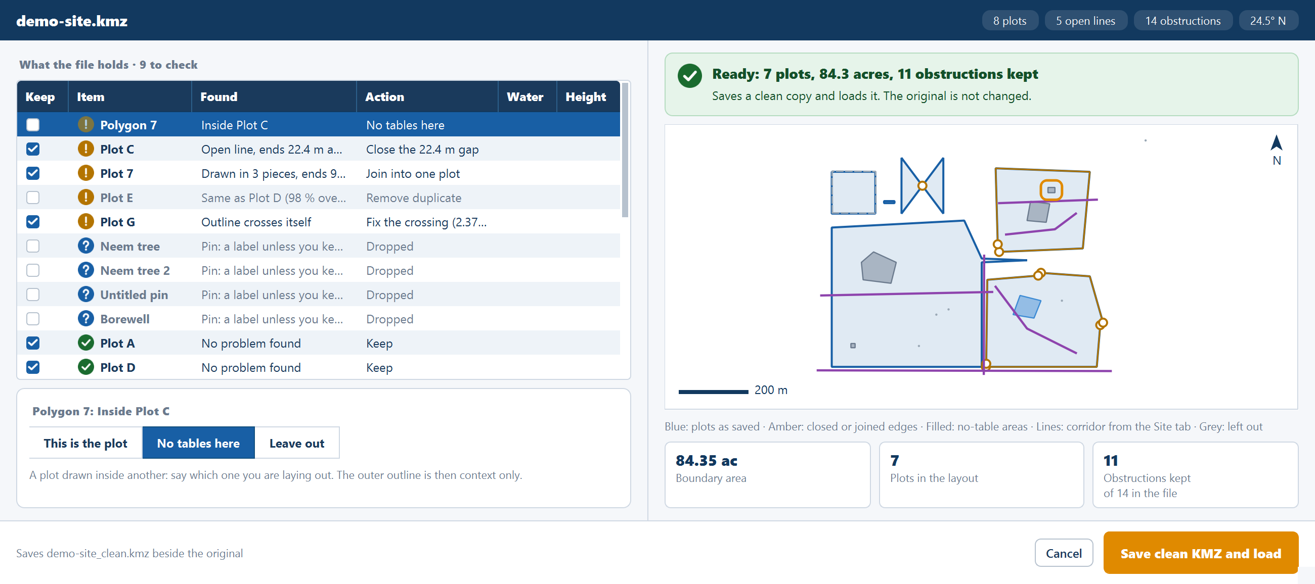
The band at the top names the file and counts what it holds: plots, open lines, obstructions and the latitude. The caption What the file holds heads a table with one row per item:
| Column | What it shows |
|---|---|
| Keep | Whether the item is used |
| Item | Its name |
| Found | What the review found, for example Open line, ends 12.4 m apart or Water: no tables here |
| Action | What will be done with it. Select a row to change this |
| Water | Whether it is drawn and booked as water |
| Height | An optional height for an area or a kept pin, so tables stay out of its shadow when Clear tables in shadows is on |
On the right, a verdict banner sums up the result, for example "Ready: 1 plot, 59.3 acres, 1 obstruction kept", above a map of the site and tiles for Boundary area, Plots in the layout and Obstructions kept.
What a problem row offers
Each problem offers its own choices. The review's recommended choice is already selected, so a file that needs nothing changed takes one click.
| Found | Choices |
|---|---|
| Open line, ends 12.4 m apart | Close the 12.4 m gap, Keep as a line, Remove |
| Drawn in 3 pieces, ends … m apart | Join into one plot, Keep as 3 lines, Remove |
| Outline crosses itself | Fix the crossing (40.98 ac), Keep as drawn, Leave out |
| Same as Plot A (100 % overlap) | Remove duplicate, Merge with Plot A |
| Overlaps Plot A by 2.1 ac | Merge with Plot A, Cut the overlap out of this plot, Remove |
| Inside Plot A | This is the plot, No tables here, Leave out |
| Outline around 3 plots | Context only, Lay it out too, Leave out |
An open line is offered as a plot only when its ends are within 50 m and it has
no name, Google Earth's own name, or a plot word such as boundary or plot.
Any other open line is a line to keep clear.
What each other row means
| Item | Reads | What it does |
|---|---|---|
| Area | "Area: no tables here" or "Water: no tables here" | Keeps tables out, with the Area setback |
| Line | "Line: no tables within the line corridor (Site tab)" or "Water line: …" | Keeps tables out by the Line corridor. Kept up to 500 m from a plot |
| Too far off to matter | "Outside the plots, not used" | A line more than 500 m from a plot, or a water polygon clear of every plot |
| Pin | "Pin: a label unless you keep it" | Kept, it becomes a spot of 1 m radius with no tables |
| A hole cut in a plot polygon | "No tables here (land cut out of the plot)" | Stays with its plot |
Only a name sets a row's Water tick to start with, and the tick changes it. No keyword picks out a transmission line or a road: every line takes the same corridor, which you set for each line on the Site tab after loading.
Warnings before saving
The window warns when the land looks wrong. None of these stops you saving, and their thresholds are in Advanced settings under Clean boundary.
| Setting | Default | Range | The warning |
|---|---|---|---|
| Outer boundary over its plots | 1.25 × | 1.01–10 | "The outer boundary adds N ac": "…the extra land may not be yours." |
| Survey map picked | 50 % | 1–100 | "You picked 62 % of the survey map": "Check the window caught only your land." |
| Plots of the file's drawing | 5 % | 0.1–100 | "The plots cover 3 % of what this file draws": "…Check the map: the boundary may not have been read." |
With more than 500 obstructions kept, the window adds "N obstructions to lay out around: Generate takes longer with this many."
Saving the clean copy
Check the verdict
Read the banner and the map. If the banner reads "No plot left to lay out", keep at least one plot: Save clean KMZ and load stays disabled with the reason "Keep at least one plot".
Click Save clean KMZ and load
The application writes <your file>_clean.kmz beside the original and loads it.
A file that is already a clean copy keeps its own name.
If the folder cannot be written to, Could not save the clean KMZ says why and asks for another folder.
Use the clean copy from then on
It reopens straight away, and asks again only about anything you add or redraw afterwards.
Cancel leaves the file unloaded; whatever was loaded before stays loaded. Saving a clean copy needs no active access.
Several plots as one piece of land
Review boundary… adds three modes above the table:
| Mode | What it does |
|---|---|
| Keep separate | The default. Each plot stays a boundary of its own. Plots that overlap are always merged, so no land is counted twice |
| One outer boundary | Replaces the plots with one boundary around them. Tight wrap follows the plots and bridges gaps up to the distance you set, 30 m to start with; a wider gap stays out, so the result can be more than one boundary. Simple outline is one plain outline around them all, which can take in land beyond your plots |
| Merge selected | Merges the plots you choose, using the Merge column |
A survey map shows the same three modes.
Survey maps
A village survey map holds numbered parcels rather than your site, so you pick
your land from it. The application recognises one from its survey-number data,
such as survey_no, gat_no or khasra, or from a polygon holding ten or more
others that cover at least half of it. Number pins such as 235 or 235/1 are
treated as labels.
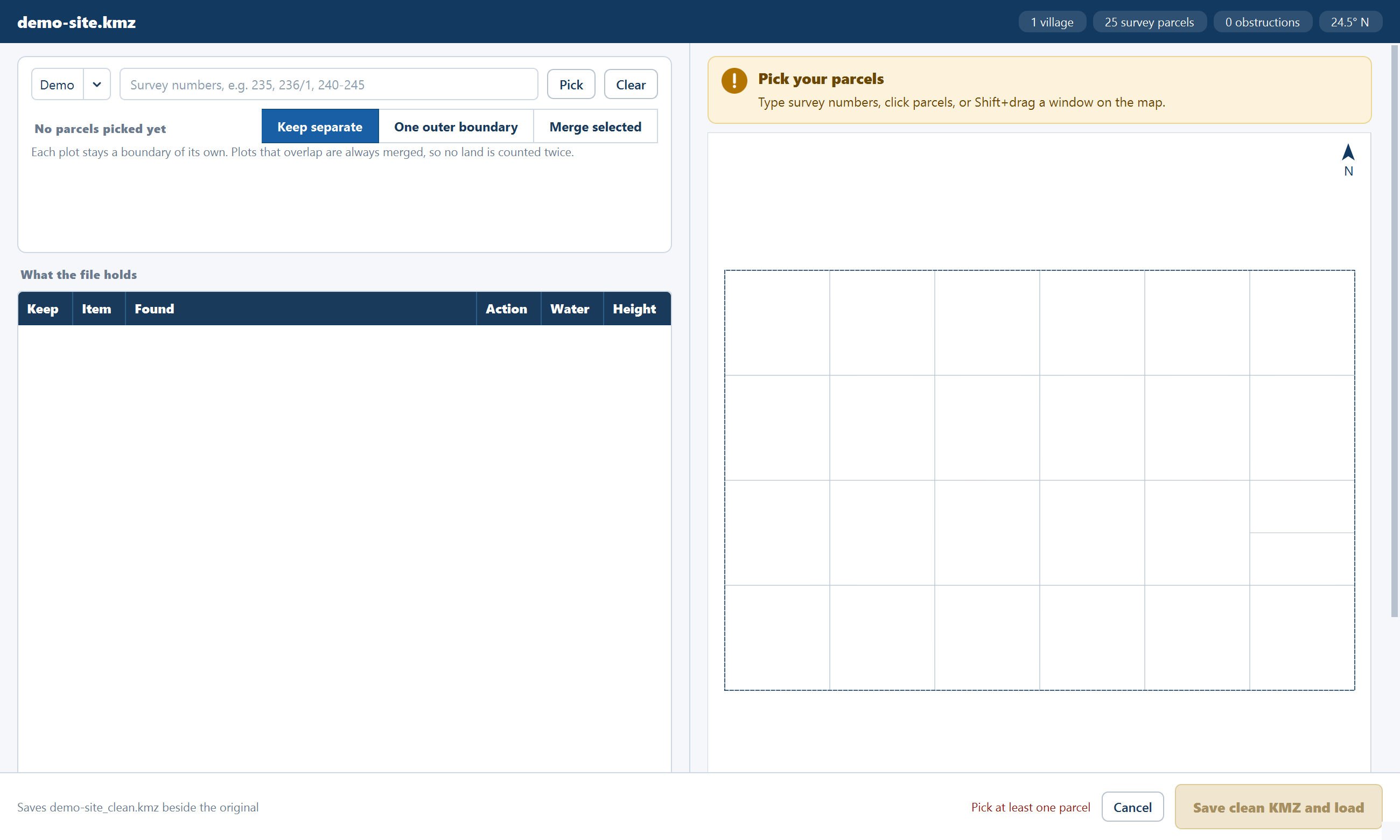
The band counts villages, survey parcels, obstructions and the latitude.
Choose the village
Survey numbers repeat from village to village, so pick the village first.
Pick your parcels
Type survey numbers and click Pick, or click parcels on the map.
| You type | It picks |
|---|---|
235 | 235 and its sub-divisions, such as 235/1 and 235/A |
235/1 | Only that one |
240-245 | Every number from 240 to 245 |
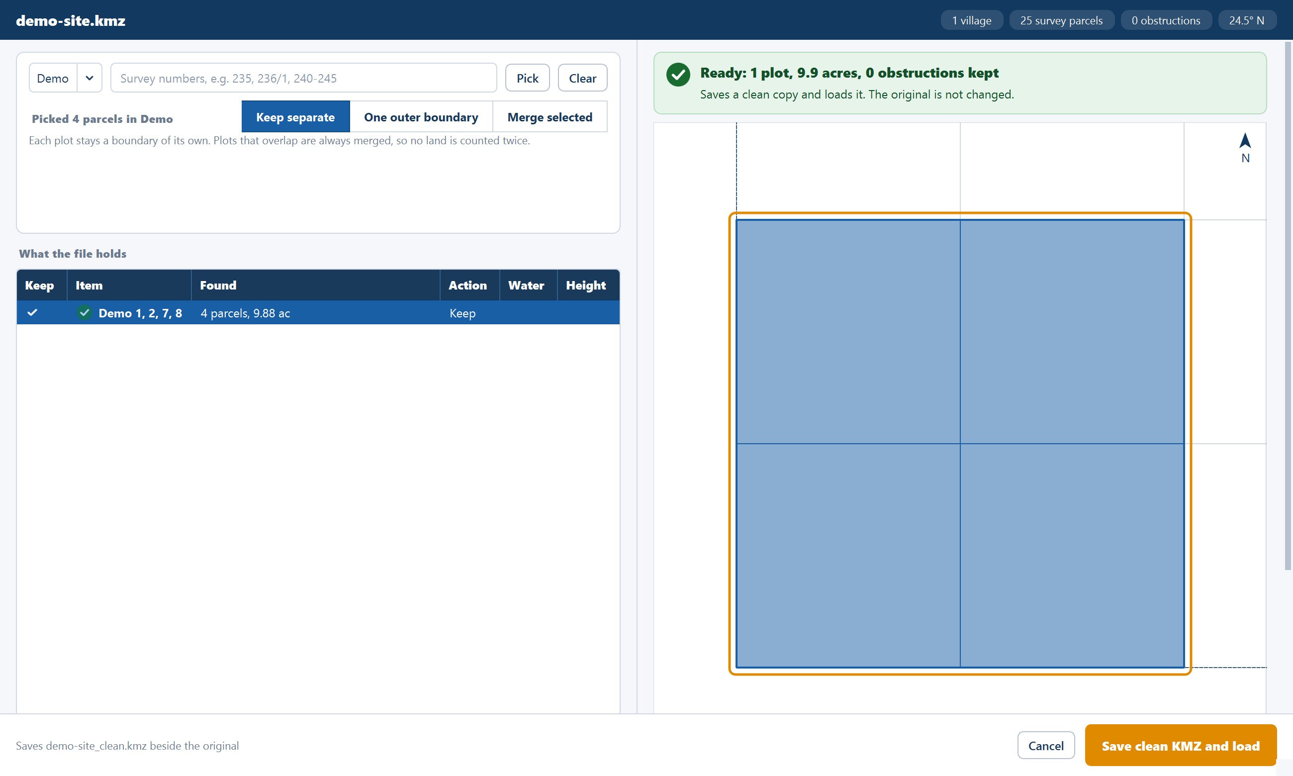
On the map, Shift+drag draws a window: left to right takes the parcels fully inside it, right to left every parcel it touches. Clicking a picked parcel unpicks it, and Clear unpicks them all. The wheel zooms, a drag pans and a double-click shows everything.
Check the plot and save
Parcels that touch become one plot. Until something is picked the banner reads "Pick your parcels" and the reason is "Pick at least one parcel".
A finished layout opened as a boundary
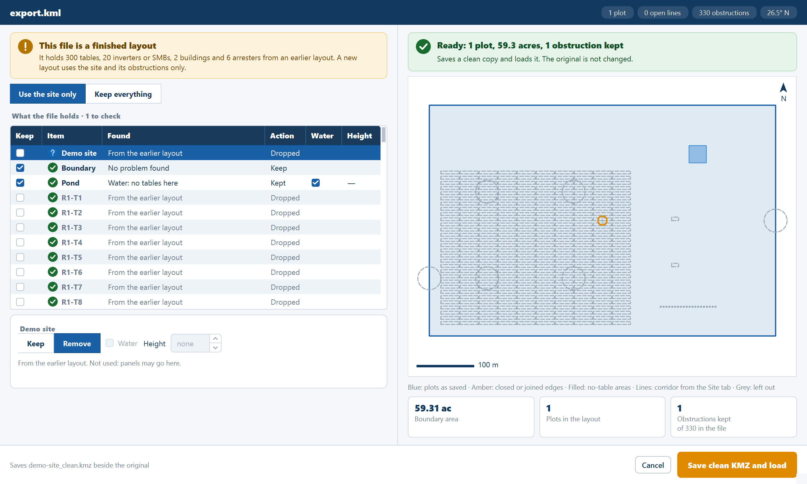
A KMZ exported from an earlier layout, by this application or another, holds the old tables and equipment as well as the site. The review recognises one and banners it: "This file is a finished layout".
| Choice | What it does |
|---|---|
| Use the site only | Drops the earlier tables, inverters, buildings and arresters, and keeps the site and its obstructions. The default for a recognised export |
| Keep everything | "Every table and building of the old layout becomes an obstruction, so little land is left for new tables." The default for a file recognised only by its pattern |
The pattern is at least 200 identical rectangles, most of them inside other polygons: "They are kept as obstructions; if they are an old layout, choose Use the site only."
A CAD export of loose lines
A drawing exported to Google Earth as many short two-point lines, with the layer named only in each line's description, is rejoined. The application names the lines from that description, joins them up, reads a layer's two banks as one area and a small tangle such as a well as one spot, then opens the window so you can check what it made.
A field survey of points only
A surveyor's file can hold nothing but points, each named with a code and a
number: rasta 12, bw_41. When every placemark is a point, there are at least
four of them and at least one run of points closes, the review traces them.
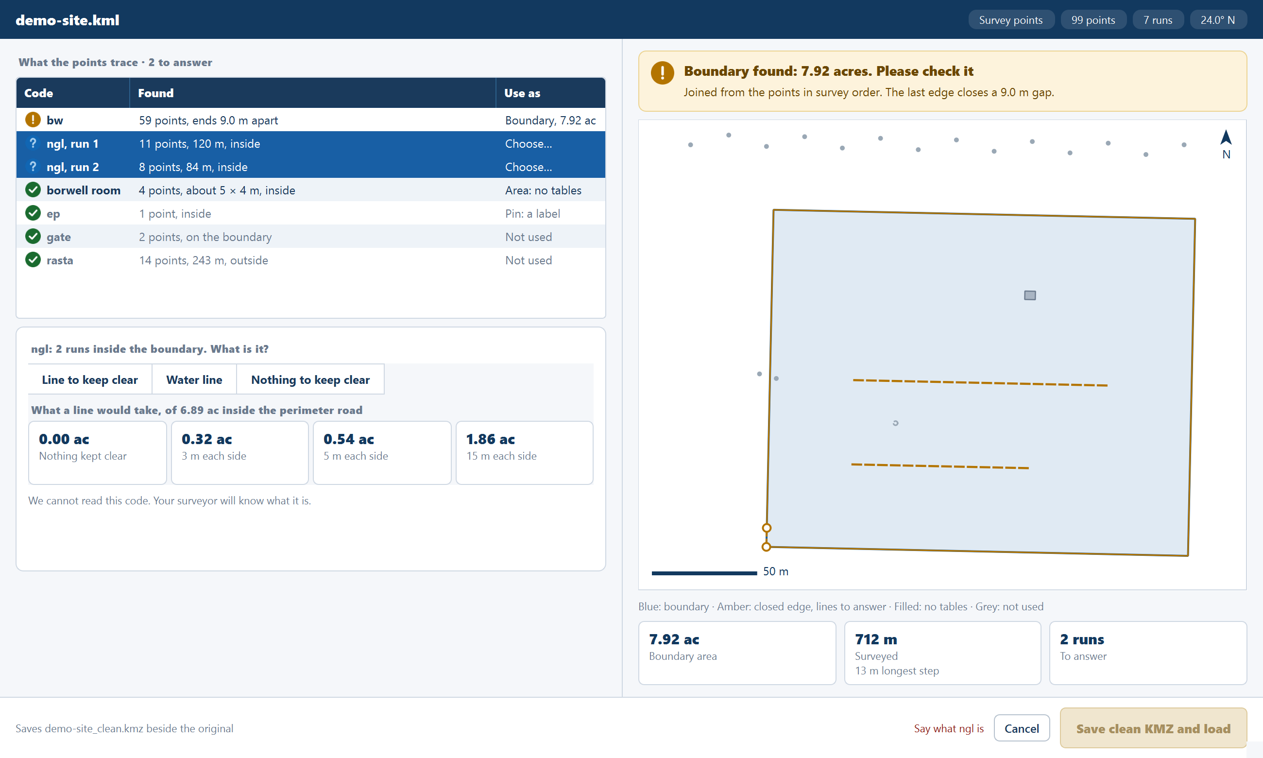
Points of one code are joined in number order, and a number that does not rise starts a new run. A run closes into a boundary when it has at least four points, its closing gap is at most 50 m and under a quarter of its length, it does not cross itself and it has the shape of a piece of land. When no run closes, nothing is guessed, and the file is reviewed as a file of pins.
The table's columns here are Code, Found and Use as:
| The run | Found, for example | Use as |
|---|---|---|
| Closes | "59 points, ends 9.0 m apart" | A boundary, which you can close, keep as a line or remove. Check it against your survey |
| One point | "1 point, inside" | Pin: a label |
| Three or more points close together, around a small area | "4 points, about 5 × 4 m, inside" | Area: no tables |
| Water-coded, open | Water line, with nothing to ask | |
| Open, three or more points, inside | "11 points, 120 m, inside" | Choose…: you say what it is |
| Two points, or outside | "2 points, on the boundary" | Not used |
Answering what a code is
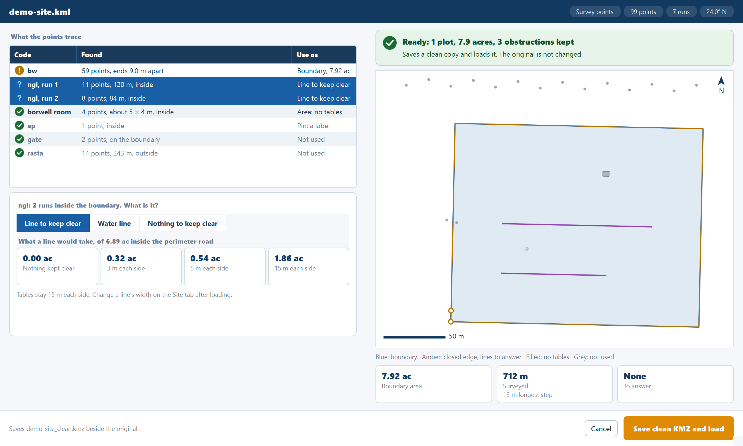
Save clean KMZ and load stays disabled, with a reason such as "Say what rasta is", until every open code has an answer. Selecting one run selects every run of its code.
Choose Line to keep clear, Water line or Nothing to keep clear. The application cannot read the code, but your surveyor will know what it is. Tiles show what a line would take of the land inside the perimeter road: nothing kept clear, 3 m each side, 5 m each side and the Site tab's corridor. With a line kept, change its width on the Site tab after loading.
A file with no plot
A closed path counts as a plot and loads with no window. A file with no plot at all cannot be laid out:
| The file holds | What you see |
|---|---|
| A named open line, or only a nala | Boundary read error: "The file has no plot: draw the site boundary as a closed polygon." |
| Only pins | The window, with Save clean KMZ and load disabled: "Keep at least one plot" |
| A survey map read without a pick | "This file is a village survey map. Pick its parcels in the boundary review first." |
Draw the site boundary as a closed polygon, save the file and load it again.
Where to go next
Boundary file requirements
How to draw and name the features in a Google Earth file, and how the Clean boundary review reads the file when you load it.
CAD drawing boundaries
Using a DXF as the plant boundary — which layer names mark water, obstructions and line corridors, and how the Site reference window says where the drawing sits.